Thursday, 20 February 2025

The Navigators toolbox- the sextant


2-The sextant

The Navigators tool chest Is full of objects and competence that enable him to determine where the ship is on the maritime globe, whether it is within the sight of land or in the middle of one of the world's large oceans.

Not only that, he or she could interpret their visible maritime world whether it be sky, sea or weather to help them make a forecast and adjust their position, all without external support.

The sextant was one of the most important tools the navigator had to enable him to fix the ships position anywhere on the ocean.

They're also precious because it was a personal instrument that every budding junior deck officer needed to invest in. In the 1950s or 1960s you either bought a German Plath model or the Kelvin Hughes from the UK.


[1]

The principle of the sextant is relatively simple. It is used to measure the altitude of celestial objects like stars, planets, and the sun and moon. Altitude being the angular elevation of the object above the visible horizon. No visible objects or no visible horizon meant that there was  no use for the sextant!

The word sextant is derived from the Latin “sextus” meaning one sixth[2].  So a sextant can measure an arc of one sixth of a circle, namely 60 degrees.  Because it has double reflecting mirrors it can measue up to 120 degrees.


[3]


[4]The instrument comprises a movable arm over a arc inscribed with angular degrees. The top of the arm has a fixed mirror attached. On the body of the instrument is a second vertically split mirror, the left side of which is clear glass. A telescope is attached to view the contents of the mirror. Each mirror has a set a filters to reduce the sun's glare. Setting the radial arm to zero degrees, you point the instrument at the celestial object, say the sun, and then by releasing

the radial arm you slowly bring the reflected sun down towards the visible horizon in the clear glass of the fixed mirror. Once you can just place the lower edge of the sun on the horizon you have measured its altitude.

Of course the sun rises and sets, but there is one altitude that is important to the navigator. That is when it has its maximum altitude, some time in the middle of the day. This is called the meridian passage because at that precise moment its bearing is south and the sun has reached its maximum altitude for that day. This altitude can help the navigator calculate latitude.


A simple diagram shows the process:

·         Measure the sun’s zenith altitude

·         The zenith distance is then 90 degrees minus the sun’s altitude

We then need to take account of the fact that the sun is inclined from the plane of its orbit around the sun by something called its declination and it varies with the time. We know this because  the sun is highest in our northern summer and lowest in winter.


[5]So we need the declination for exactly the time we took the altitude reading and this comes from another item in the navigators toolbox, the Nautical almanac where we can find the declination we want.

For northern latitudes, in the summer period the declination will be northerly so a calculation is: With an altitude of 47 degrees, the zenith distance is 90 degrees minus sun altitude = 43 degrees.

From the almanac the declination is 10 degrees north so latitude is 43 + 10 = 53 degrees north.

I should explain that this is a simplified example and for other latitudes and declination the calculation will vary. Also, there are a number of corrections to be made to the sextant and the observed sun’s altitude that the navigator must make.


References

‘Brown’s Nautical Almanac - Google Search’. Accessed 21 January 2025. https://www.google.com/search?sca_esv=68f5f289e15608b2&sxsrf=ADLYWIKGrRTYhttgFFByyiliSP6-e4e2DQ:1737457710086&q=brown%27s+nautical+almanac&udm=2&fbs=AEQNm0Aa4sjWe7Rqy32pFwRj0UkWd8nbOJfsBGGB5IQQO6L3J_TJ4YMS4eRay1mUcjRHkZxQmI-azE4-kvfPRbUUVQX-VdukAcnN3WyeChzMt5JDRBMtwKF_X1ZFdhHy6uNqBY-4IVOFfEGiyJu7GCSojJTrLQS8W8-G9DpcjCnldC9L40SzLN0&sa=X&ved=2ahUKEwikv_ys1oaLAxXnQlUIHaikMTUQtKgLegQIFRAB&biw=1136&bih=480&dpr=1.1#vhid=PK2xbiJKjwohgM&vssid=mosaic.

‘Definition of Sextant - Google Search’. Accessed 20 January 2025. https://www.google.com/search?q=definition+of+sextant&oq=definition+of+sextant&gs_lcrp=EgZjaHJvbWUyDggAEEUYORhGGPkBGIAEMggIARAAGBYYHjIICAIQABgWGB4yCAgDEAAYFhgeMggIBBAAGBYYHjIICAUQABgWGB4yDQgGEAAYhgMYgAQYigUyCggHEAAYogQYiQUyCggIEAAYgAQYogTSAQkxMDgxOGowajeoAgCwAgA&sourceid=chrome&ie=UTF-8.

Malm, Bengt. Bengt Demo. of Sextant. n.d. Photo.

‘NOVA Online | Shackleton’s Voyage of Endurance | How a Sextant Works | PBS’. Accessed 14 January 2025. https://www.pbs.org/wgbh/nova/shackleton/navigate/escapeworks.html.

‘Sekstant’. Accessed 20 January 2025. https://digitaltmuseum.no/011024215631/sekstant.


Acknowledgements

·         Bengt Malm, Ancient Mariner and volunteer colleague Norwegian Maritime Museum, Oslo

·         Camilla Nordeng, conservator Norwegin Maritime Museum, Oslo


[1] ‘Sekstant’.

[2] ‘Definition of Sextant - Google Search’.

[3] Malm, Bengt Demo. of Sextant.

[4] ‘NOVA Online | Shackleton’s Voyage of Endurance | How a Sextant Works | PBS’.

[5] ‘Brown’s Nautical Almanac - Google Search’.

Thursday, 16 January 2025

British Seamen’s Discharge Book

 Three generations of seafaring

A seamen’s discharge book is a record of the employment of a seafarer. All seafarers need one and it is issued by the maritime authority of the country the seafarer is a citizen of.[1]

I am lucky to have the discharge books of my grandfather, father and myself over a period of 80 years. Collectively they tell a story of ships, employment and voyages from the 1890’s to the 1970’s. This article will describe the changes in discharge book entries over three generations.

The hard bound cover of the book has changed little over this period.


The colours and wording may have changed on the covers but from the black edition of my grandfather through the red one of my father to my blue one, they all serve the same purpose, to catalogue the voyages of the holder and provide a character reference for each voyage.

You might be wondering why there are 4 books for three mariners. The twist and turns of our time at sea through two world wars will reveal many interesting events that will explain this apparent anomaly.

Let’s look inside my father’s discharge book. The first page holds personal details that identify the seafarer and their next of kin.

Much like a passport it provides evidence of identity. However, there is an interesting handwritten comment in the upper right corner.

Renewal, original lost when vessel sunk by enemy action!

Therefore, there are no earlier discharge book records of my father. More on this later.


Photographs were included later. My personal record page shows a gawky 16-year-old schoolboy before his first trip to sea.


The first British discharge books were issued around 1900[2] and were identified by a number until around 1920 when a decision was made to renumber then with the prefix R.

My grandfathers discharge book number is 163200 with a first entry of February 1901. My father had 2 books numbered R123850 with a first entry 9.7.39 and the second book also numbered R123850. The reason for two books is that one was lost on the SS Stonegate that was sunk in WW2. See the story here. My discharge book issued in 1957 is R677594.

However, my grandfather, FGW Randall, was indentured to a Whitby shipowner Richard Smailes for 4 years starting in 1898 at the age of 15 before discharge books were issued in the UK.

Subsequently his record of ship employment until early 1900’s was on individual paper certificates. Here is his first one. One interesting item is that normally you start a voyage in port and the fact is verified by the local marine office. Here it states his engagement was “At Sea” and there is no official stamp. It was unusual for someone to join a ship away from a port where there was a marine office. It can mean literally he joined at sea from another ship or boat or at a port without a marine office.


Entries in the discharge book are made by the Captain and the British Maritime authority at the port of engagement or discharge. There can be multiple entries on each page.

In the early discharge books a voyage entry took two pages, one for voyage details and another for the captain to report on the seaman. In my grandfather’s discharge book seen above you can see details of the ship, the date and port of engagement, the rank of the seaman, the port and date of discharge, a brief statement on the voyage and the signature of the master.

The second page was divided in two, each side relating to a voyage on the previous page and reporting on the seaman during the voyage. There are two aspects of character, “ability” (assume that relates to job specification for the rank of the seaman) and “for general conduct” probably relating to his conduct in a team/social environment.

There are two possible entries “VG” or “DR”. Very good or Decline to Report. The latter can have consequences for future employment.

Note that it is the master who makes this report, and it is endorsed by the marine authority at the discharge port.


30 years later my fathers discharge book was a little different.
Now both the record of a voyage and the character report on the same double page layout. Note the entry in the first row relating to the SS Stonegate. He was discharged at sea and under the column for the voyage description it states, “Ship sunk”. This relates to the article I referred to earlier. Note also the captain making the report is my grandfather!! They served on the same ship.

There is little change over the next 20 years until I went to sea as an apprentice officer.

The only element is that the masters never recorded the ships I was on during my indentured 4-year period. Hence, I have no record of the ships I served on, but I do remember I sailed to India and back a number of time whilst sometimes calling at the southern states of America after Port Said before returning to Liverpool.

 You may have noticed that the first image had four discharge book covers. Well, my father had a new discharge book after a long layoff from the sea. Now he was a Captain, the person who makes the reports in a seamen’s discharge book so why did he need a discharge book. The rules are clear everyone needs one so he was issued with one that only related to voyage descriptions, presumably because a Captain should report on his own character!


So the discharge book is an important certificate for its owner and a valuable source of information for those interested in writing about the voyages of seafarers. More on this later.

References

GOV.UK. ‘Get a Seaman’s Discharge Book or British Seaman’s Card’. Accessed 19 November 2024. https://www.gov.uk/get-seamans-discharge-book-or-british-seamans-card.

Ships Nostalgia. ‘Discharge Book Numbers’, 18 November 2005.


https://www.shipsnostalgia.com/threads/discharge-book-numbers.288819/.


Acknowledgement

I need to recognise the detailed search work of my brother Peter E. Douglas, the family archivist


[1] ‘Get a Seaman’s Discharge Book or British Seaman’s Card’.

[2] ‘Discharge Book Numbers’.

Tuesday, 17 December 2024

Understanding your magnetic compass


 As a seafarer

The magnetic compass has been the main directional tool in the seafarer’s toolbox

to try and determine true north and then use that information for steering a course or take a bearing to fix position. The problem is that it has errors[1].

Let us take a closer look at a  ships magnetic compass. Today it is likely to be found on the monkey island as a backup to satnav systems but is still a requirement on ships.

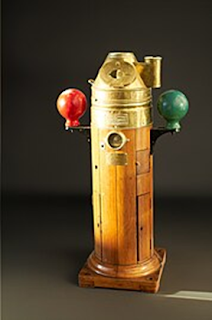
The compass card is a magnet overlaid with a card holding the points of the compass. The card has a pivot and is mounted in a bowl filled with alcohol and water to dampen the movement of the card. The bowl is then mounted in a  set of gimbals so that the compass remain as horizontal as possible with  the ships motion and the complete magnetic compass is installed in a wooden stand called a binnacle.

The binnacle provides housing also for important tools to minimise compass errors.

[2]


The first challenge is that the magnetic compass north seeking pole points toward the earth’s magnetic north pole and that is not the same as the true north pole and worse still it is on the move as the image here shows! That means there is a changing error between the true north pole and the magnetic north pole as indicated the magnetic compass. The earth’s magnetic field influences the ships magnetic compass in all places on the planet.

This error is called “variation” and needs to be included in corrections to the

magnetic compass heading. 

That information can be found on the chart currently been used. In the centre of the compass rose is a second rose showing the magnetic headings for that region and stating the current variation as several degrees east or west of the true north. In this example magnetic north is to the left or west of true north.  It is also includes a date with information on the annual change in variation for that region. Hence the navigator can accurately retrieve the current variation for his ship’s magnetic compass.

A more complex challenge is based around the fact that steel ship is also magnetised, and this affects the position of the magnetic compass north seeking pointer.

It is complex because there are two distinct effects, one by the permanent magnetism in the ship whose effect does not change with course or behaviour of the ship and one that is induced by the earth’s magnetic field that changes the polarity and strength of the ship’s magnetism with course , rolling and pitching of  the vessel.

This is where the binnacle housing containing the compass plays a role in minimising the deviation to the compass needle from the ship’s magnetism.

To minimise the effect of the permanent ship’s magnetism magnets are placed both fore and aft and athwartship in the binnacle and to cope with rolling behaviour there is a magnet placed in a swinging bucket immediately below the compass in the binnacle.

[3]But what about the induced magnetism of the ship whose strength and polarity changes with ships course? Here we have Kelvins balls, those soft iron spheres each side of the compass and for the vertical component we have a vertical brass tube in front of the binnacle that contains a soft iron cylinder which with its own induced magnetism counteracts the deviation of the needle.[4]

All these adjustments are carried out by a compass adjuster by “swinging the ship” to determine the deviation of the compass. This produces a deviation curve which the navigator can use to allow for the deviation of the compass as well as the variation from the earth’s magnetic field.

As the variation and deviation are measured in degrees west or east of the compass needle, a mnemonic is a simple way to remember how to make correction to the magnetic heading.

These rules are often combined with the mnemonic "West is best, East is least"; that is to say, add W declinations when going from True bearings to Magnetic bearings, and subtract E ones”.[5]


References

‘Binnacle’. In Wikipedia, 2 November 2024. https://en.wikipedia.org/w/index.php?title=Binnacle&oldid=1254943793.

Cohen, Ofer. ‘Earth’s Magnetic Field Protects Life on Earth from Radiation, but It Can Move, and the Magnetic Poles Can Even Flip’. The Conversation, 27 November 2023. http://theconversation.com/earths-magnetic-field-protects-life-on-earth-from-radiation-but-it-can-move-and-the-magnetic-poles-can-even-flip-216231.

‘Magnetic Declination’. In Wikipedia, 25 September 2024. https://en.wikipedia.org/w/index.php?title=Magnetic_declination&oldid=1247777714.

Nguyen, Van Suong. ‘Calculation of the Deviation Coefficients for Marine Magnetic Compass’. Journal of International Maritime Safety, Environmental Affairs, and Shipping 2, no. 2 (8 February 2019): 112–15. https://doi.org/10.1080/25725084.2019.1569336.

Why Do Ships Have Two Balls?, 2023. https://www.youtube.com/watch?v=ckhPRie1iKk.


[1] ‘Binnacle’.

[2] Cohen, ‘Earth’s Magnetic Field Protects Life on Earth from Radiation, but It Can Move, and the Magnetic Poles Can Even Flip’.

[3] Nguyen, ‘Calculation of the Deviation Coefficients for Marine Magnetic Compass’.

[4] Why Do Ships Have Two Balls?

[5] ‘Magnetic Declination’.

The Navigators toolbox-marine log

  [1] Background The compass, sextant, chronometer, and radar are tools that fix the ships position on a chart, meaning the position i...