Tuesday, 17 December 2024

Understanding your magnetic compass


 As a seafarer

The magnetic compass has been the main directional tool in the seafarer’s toolbox

to try and determine true north and then use that information for steering a course or take a bearing to fix position. The problem is that it has errors[1].

Let us take a closer look at a  ships magnetic compass. Today it is likely to be found on the monkey island as a backup to satnav systems but is still a requirement on ships.

The compass card is a magnet overlaid with a card holding the points of the compass. The card has a pivot and is mounted in a bowl filled with alcohol and water to dampen the movement of the card. The bowl is then mounted in a  set of gimbals so that the compass remain as horizontal as possible with  the ships motion and the complete magnetic compass is installed in a wooden stand called a binnacle.

The binnacle provides housing also for important tools to minimise compass errors.

[2]


The first challenge is that the magnetic compass north seeking pole points toward the earth’s magnetic north pole and that is not the same as the true north pole and worse still it is on the move as the image here shows! That means there is a changing error between the true north pole and the magnetic north pole as indicated the magnetic compass. The earth’s magnetic field influences the ships magnetic compass in all places on the planet.

This error is called “variation” and needs to be included in corrections to the

magnetic compass heading. 

That information can be found on the chart currently been used. In the centre of the compass rose is a second rose showing the magnetic headings for that region and stating the current variation as several degrees east or west of the true north. In this example magnetic north is to the left or west of true north.  It is also includes a date with information on the annual change in variation for that region. Hence the navigator can accurately retrieve the current variation for his ship’s magnetic compass.

A more complex challenge is based around the fact that steel ship is also magnetised, and this affects the position of the magnetic compass north seeking pointer.

It is complex because there are two distinct effects, one by the permanent magnetism in the ship whose effect does not change with course or behaviour of the ship and one that is induced by the earth’s magnetic field that changes the polarity and strength of the ship’s magnetism with course , rolling and pitching of  the vessel.

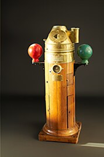
This is where the binnacle housing containing the compass plays a role in minimising the deviation to the compass needle from the ship’s magnetism.

To minimise the effect of the permanent ship’s magnetism magnets are placed both fore and aft and athwartship in the binnacle and to cope with rolling behaviour there is a magnet placed in a swinging bucket immediately below the compass in the binnacle.

[3]But what about the induced magnetism of the ship whose strength and polarity changes with ships course? Here we have Kelvins balls, those soft iron spheres each side of the compass and for the vertical component we have a vertical brass tube in front of the binnacle that contains a soft iron cylinder which with its own induced magnetism counteracts the deviation of the needle.[4]

All these adjustments are carried out by a compass adjuster by “swinging the ship” to determine the deviation of the compass. This produces a deviation curve which the navigator can use to allow for the deviation of the compass as well as the variation from the earth’s magnetic field.

As the variation and deviation are measured in degrees west or east of the compass needle, a mnemonic is a simple way to remember how to make correction to the magnetic heading.

These rules are often combined with the mnemonic "West is best, East is least"; that is to say, add W declinations when going from True bearings to Magnetic bearings, and subtract E ones”.[5]


References

‘Binnacle’. In Wikipedia, 2 November 2024. https://en.wikipedia.org/w/index.php?title=Binnacle&oldid=1254943793.

Cohen, Ofer. ‘Earth’s Magnetic Field Protects Life on Earth from Radiation, but It Can Move, and the Magnetic Poles Can Even Flip’. The Conversation, 27 November 2023. http://theconversation.com/earths-magnetic-field-protects-life-on-earth-from-radiation-but-it-can-move-and-the-magnetic-poles-can-even-flip-216231.

‘Magnetic Declination’. In Wikipedia, 25 September 2024. https://en.wikipedia.org/w/index.php?title=Magnetic_declination&oldid=1247777714.

Nguyen, Van Suong. ‘Calculation of the Deviation Coefficients for Marine Magnetic Compass’. Journal of International Maritime Safety, Environmental Affairs, and Shipping 2, no. 2 (8 February 2019): 112–15. https://doi.org/10.1080/25725084.2019.1569336.

Why Do Ships Have Two Balls?, 2023. https://www.youtube.com/watch?v=ckhPRie1iKk.


[1] ‘Binnacle’.

[2] Cohen, ‘Earth’s Magnetic Field Protects Life on Earth from Radiation, but It Can Move, and the Magnetic Poles Can Even Flip’.

[3] Nguyen, ‘Calculation of the Deviation Coefficients for Marine Magnetic Compass’.

[4] Why Do Ships Have Two Balls?

[5] ‘Magnetic Declination’.

Friday, 22 November 2024

Seamen need to be able to tie knots


This seems an obvious statement but without the ability to handle  ropes and use knots it is just not possible to be competent as a basic seafarer. This is particulalry relevant to traditional clinker built boats where there are no hydraulics or electricty to help you. You just have ropes that need to be attached to various parts of the boat. This subject has many opinions on which knot to use in a particular circumstance.

We will use Vaaghals as an example where we use 7 basic knots that are used to operate the boat.

Bowline (Pålestikk)

This is a general purpose knot often used to form a loop or bight in the rope so it can be passed through or over mooring cleats or posts. It is also used to attach a brace (bras) to each end of a yard (rå). It does not slip under load and can be difficult to untie after use if it has had a lot of tension on it.

Reef knot (Båtsmannsknop)


As the term applies it is used to tie together the two ends of the reefing lines in the sail and also used to tie the square sail to the yard. It is best for ropes or rope  ends of the the same size as it is likely to slip if different diameter rope are used or different rope types such as natural fibre and plastic ropes.

A common mistake in tying this knot is to forget the sequence of tying the ends. Remember «Left over right and then left under right» will produce the correct knot. It generally is tight under a constant load but can unravel if the load on the knot varies.

Timber hitch (Tommerstikk)


The timber hitch is a quick and easy knot to use where a constant load is applied. On a traditional square sail rig it is often used to attach the halliard to the sails yard. Note it generally applies to small boats such as Vaaghals.

Note also that the halliard passes down behind the yard on the mast side and then is tucked back on itself at least three times. The tucks should therefore be facing away from the mast.The number of tucks really depends on the diameter of the yard. The more tucks the better. The knot is easily undone when the load is taken off  the rope.

Figure-eight knot (Stoppeknute)


The figure of eight knot is self evident in its makeup and is quickly tied. Its main use is as a «stopper knot» so that the end of a rope cannot run out of a block or attachment hole. Most often used for the sheets controlling the sail but generally where you do not want to lose  the end of a rope. As it is a jamming knot it can be difficult to untie.

Rolling hitch (Vantstikk)


This knot is a «jamming» knot in that it tightens and holds fast under load. It is often used to take the tension off a rope in order to undo it. The important element is that the second turn must cross the first one before belaying with a half hitch. This creates a jamming kink in the rope the knot is attached to. It is also used in traditional wooden boats to tighten and hold the shrouds in place by applying the end of the shroud back on itself in cases where there are no deadeyes. It works best with natural fibre ropes and is known to slip with plastic ropes.


Round turn and two half hitches (Dobbelt halvstikk om egen part)


As the name implies the knot is applied to a spar or object by first passing the rope around the spar and then adding two half hitches to the standing part. A variation of this knot passes the rope behind the standing part before completing the turn and half hitches(bøyestikk). A very secure knot of general use.


Clove hitch (Dobbelt halvstikk)


Another very usefull general knot for tying off the end of a rope. Used for fenders, mooring etc. With variable load on the rope it can unloosen. A variation of the knot has the final half hitch «slipped» with a loop so it can easily be undone.

Monday, 14 October 2024

Trip to the wilds of Nesodden


An adventure for the Båtlab gang

It all started about two years ago when two of our colleagues, Charlotte and Camilla, announced that they would not be around the Norwegian Maritime Museum for some time, as they were involved in a large project to move all the cultural items stored in Ekeberg to a new storage location near Drøbak.

This was very sad for us, as with Charlotte we had learned a lot on traditional clinker-built boats by working with the boat builders on the reconstruction of Norwegian boats. In fact, 4 boats in total.


With Camilla, we learnt much on the conservation of cultural artefacts, especially boats, rubber gloves included.

 So, they disappeared and then later, we had an invitation from Camilla for an orientation tour on a new warehouse, located in the countryside around Nesodden. This would be exciting as we had spent some time working with Charlotte and Camilla in the caves of Ekeberg and anything had to be a better working environment than that.


We were four experienced navigators so expected no difficulty in driving down to the warehouse. three in one car and the fourth driving from another town It didn't turn out like that though.

A pleasant drive south with the three navigators towards Drøbak was suddenly shattered when we realised, we had passed the recommended turn off for the warehouse. Not to worry, said navigator 1, we have GPS in this new car.

He duly typed in the address given to us by Camilla. The computer-generated map instructed us to take the next turning and head towards Drøbak. Problem solved, we thought, and we proceeded along country roads for some kilometres, passing a local church in the countryside. This did not seem right, so we turned round, and our wonderful computer immediately gave us another route and we should turn into a narrow lane skirted by several houses and a farm. Our second navigator, very experienced in the navigation of ships, pointed out that often these lanes deteriorate quickly and so it did. First the asphalt disappeared to be replaced by a gravel surface. So long as we do not get grass in the middle of the road, we should be OK as it means that the road is well used, said our second navigator. A few kilometres on grass appeared in the middle of the road. This does not look too good, said the third, navigator from the back seat, a little confused being more used to navigating by sun and compass.

 It will be OK, said Navigator 1, so long as we do not meet a road barrier. At that moment, the GPS screen showed the road ended in a barrier! So, we must turn around and return to the Church Road.

Completely disorientated, the 3 experienced navigators counselled that the wise thing to do was to go back until we saw a sign for Drøbak. This we did and we reintroduced the address into the GPS which seemed as confused as us by constantly wanting us to turn back toward Drøbak.

Three times we arrived at the same roundabout only to be instructed to take the road back to Drøbak. Time for a radical solution. Out with Google Maps on our mobiles and Navigator 3 in the back seat confirmed he had our position plotted and could give verbal directions to navigate to our goal.

 After several missed turns we finally arrived at our destination, somewhat bewildered and a little subdued that the combined might of many years maritime navigation could not solve this challenge. Our excuse could be that there was no sun in evidence, we lacked a sextant and had no compass!

However, we had arrived at the new warehouse for the Norwegian Folkemuseum, better late than never! Surprisingly our fourth navigator had already arrived and wondered why it had takes so long as he had no such navigation challenges. The moral of the story is never to travel with three navigators in the same car!

Camilla was there to welcome us, and we entered this new HUGE building, met the rest of the conservation team and started our orientation tour.

First impressions were WOW, three floors for artifacts, offices seminar room,


kitchen and offices and even toilets. What a difference to Ekeberg. But the first surprise was the sheer size of each floor, possibly 2 football fields in area they were light air-controlled spaces with plenty of room to move around and work with objects, even had lifts between floors! The third navigator was heard to state “fantastic” multiple times!!

It soon became apparent of the scale of the move from Ekeberg. Some 3500 artifacts must first be identified, registered in a database, cleaned and set in a logistics plan for moving. Only then could the items be transported. At the new site a completely new system of storage was built with racks and pallets and wheeled cradles for the 70 odd boats.

Each of the items had an ID , a location and a barcode providing its history where known.

No wonder we did not see Charlotte and Camilla for 2 years.

The result is a breathtaking new modern warehouse for cultural artifacts of the Museum. Many thanks to the team down there and especially to Charlotte and Camilla.

PS. We all made it back to Oslo without incident!


Sunday, 13 October 2024

Maritime situational awareness

One of the critical competencies a seafarer needs is situational awareness, being alert to his or her environment and being able to analyze the situation and make informed decisions.

A formal definition:

The term situational awareness can be defined as how elements are viewed within their surroundings, relative to time and space, and how to foresee or predict the occurrence of events by understanding trends and patterns.[1]

Lack of this competence can lead to navigational errors that can be disastrous.

A survey of practising seafarers using a bridge simulator found that over 50% of them failed to recognise a navigational fault even when there were audio and visual cues[2].

A report by the Norwegian Maritime safety authority into a recent collision between a Norwegian warship and a tanker off the Norwegian coast had several safety recommendations. One of these (Marine No 2019/06T) stated:

«The navigator in charge did not pick up on the signals of danger or that the navigator’s own situational awareness was inaccurate. A more experienced navigator would have been better equipped to realise this. »[3]


So what is situational awareness? Let’s use a deck officer on watch as an example.

Many scholars break it down into three levels in sequence.

1.      The perception of the elements in the current environment means that a navigator can identify ships and objects around him or her, can identify alarms or signals on the bridge.

2.      Comprehension of the situation meaning that the navigator understands the situation and the likely risks involved.

3.      A decision-making phase where the navigator acts in response to the perceived risk.

An example helps clarify the principles.

It is nighttime and the navigator is in maritime traffic and identifies a ship approaching. Either by radar or visually he ascertains that there is the likelihood of a collision. The classic «end on» scenario. Once understood it is the navigator’s responsibility to make a decision following the International Collision regulations and alter course to starboard to avoid the oncoming vessel. That way the risk of a collision is averted.

This is a simplified version and there can be many factors that can make the situation more complex such as limited manoeuvrability, fatigue or lack of competence of the navigator. Nevertheless situational awareness practice is central to the operation and inability to understand what is happening around the navigator is a major cause of human error accidents at sea.

The navigator is not always alone on the ridge but works in a team utilising the tools of bridge resource management where situational awareness is a key component.


[4]There is another dimension to situational awareness that should not be discounted. Ones senses. It may be that as Captain in your cabin on an ocean crossing you hear a change in the background noise of engine, wind and waves. This alerts to a new situation, either planned or not. The change in motion of the ship would be another source of concern. Differentiating the sound of one alarm from another can be critical in decision-making.

So the senses also play an important role in situational awareness.


References

‘2019-08 KNM Helge Ingstad Og Sola TS Eng (1).Pdf’, n.d.

Chan, Jevon P., Rose Norman, Kayvan Pazouki, and David Golightly. ‘Autonomous Maritime Operations and the Influence of Situational Awareness within Maritime Navigation’. WMU Journal of Maritime Affairs 21, no. 2 (1 June 2022): 121–40. https://doi.org/10.1007/s13437-022-00264-4.

Knudsen, Anne. ‘Bridge Resource Management (BRM/MRM) | Definition’. NaviMinds (blog), 6 December 2023. https://naviminds.com/bridge-resource-management/.


[1] Chan et al., ‘Autonomous Maritime Operations and the Influence of Situational Awareness within Maritime Navigation’, 4.

[2] Chan et al., page 138.

[3] ‘2019-08 KNM Helge Ingstad Og Sola TS Eng (page 148).Pdf’.

[4] Knudsen, ‘Bridge Resource Management (BRM/MRM) | Definition’.

Thursday, 15 August 2024

A feast of traditional Yorkshire food

 Like all food, regional diversity in Yorkshire is no exception.

 Of course, everyone knows about Yorkshire puddings, or do they?

A Yorkshire pudding is not some soggy sponge like batter that you eat with your


Sunday roast, but a light, fluffy, crispy cup like dough that is filled with gravy.

A real insult to a Yorkshire person is to serve the Yorkshire pudding with the main course. It should be eaten alone as a starter. The reason for this is pure Yorkshire. Fill ’em up with Yorkshire pudding and they won't want as much main course! Thriftiness is a Yorkshire trait always to be followed!

Of course, if you come from Nottinghamshire, you would eat your Yorkshire pudding with jam as a dessert. But then again, they're really daft from down there!

A variation on the Yorkshire pudding is “toad in the hole”, a large Yorkshire pudding with sausage embedded in the mix. Very filling.


Then there are kippers, another essentially Yorkshire fish delicacy. In my youth, my brother and I would visit Whitby., walk across the bridge to the east side to buy kippers from Nobles, the fishmonger. You know you're in the right area because there were those sheds emitting a lot of smoke, the curing houses. A kipper, for the uninitiated, is a smoked herring. It is gutted, flattened out and hung up to smoke.


We ate ours for breakfast, best poached and sometimes with the poached on top. Delicious.


Another Yorkshire rarity is the pikelet, which in the south they call a crumpet. It is a griddle bread made from flour., water and yeast. Like a pancake but thicker and full of holes. Best toasted and loaded with butter as a breakfast delight.

 Then there is Yorkshire Brack, a moist fruit cake not unlike English Christmas

cake. But with a difference. The dried fruit are first soaked in Yorkshire tea not alcohol before mixing and baking to produce a fruit loaf.


What about Yorkshire tea, blended in Harrogate and producing a strong cuppa.

Finally, Yorkshire, like many northern regions, likes afternoon tea.

It is a meal around 4:00 PM served in many hotels and especially tea rooms. Those special afternoon cafes offering cafes offering cakes, pikelets and the final


Yorkshire Delight, the Curd Cheesecake. Sometimes called Yorkshire Curd Tart. Made of fresh curd and including currants and egg, it tops off a fine afternoon tea.

Enjoy.

The Navigators toolbox-marine log

  [1] Background The compass, sextant, chronometer, and radar are tools that fix the ships position on a chart, meaning the position i...